
Ballan wrasse
The environment line for the ballan wrasse carries two depth pairs: a range of 1 to 50 m, and an usual band of 2 to 30 m. Both are on the same page, one after the other, and they answer different questions. The first marks the full span on file; the second marks where the fish is normally met. Between those two statements sits most of the confusion about how to fish a rocky coast.
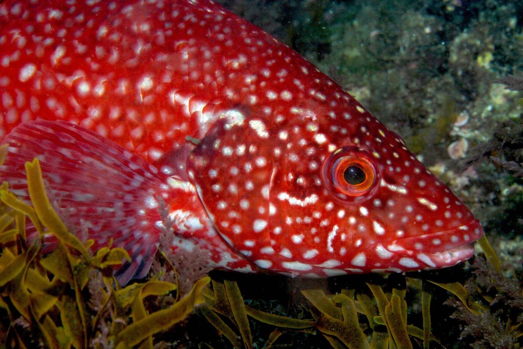
The environment line for the ballan wrasse carries two depth pairs: a range of 1 to 50 m, and a usual band of 2 to 30 m. Both are on the same page, one after the other, and they answer different questions. The first marks the full span on file; the second marks where the fish is normally met. Between those two statements sits most of the confusion about how to fish a rocky coast.
1 to 50 m is not one habitat
Fifty metres is a long way down a rock face, and one metre is a rock pool at low water. A single line joining them is a record of extremes, not a description of a neighbourhood. The ballan wrasse is reef-associated and temperate in the same entry, and the two labels cover quite different sea floors: kelp-covered boulders near the surface, and deeper rock further out.
Treating the outer number as the target is the usual mistake. A 50 m mark is usually reached from a boat in this range, and a fish recorded there is not the same fish as the one in the weed at two metres.
Working depth: 2 to 30 m
The usual-depth pair is 2 to 30 m, and it is the more useful number for anyone standing on a shore. It brackets the kelp zone, the boulder slopes and the shallow reef edge where the species is commonly caught. The 1 m figure below it is the exception: a low-water rock pool, not a routine mark.
Read the band as a starting window, not a guarantee. The entry gives no seasonal shift and no figure for where inside 2 to 30 m the fish concentrates. It simply says that most records fall there. Citizen records point the same way: iNaturalist carries 1,760 observations for this taxon. A plan that begins shallow and works outward is consistent with the number; a plan that begins at 45 m because the maximum says 50 is not.
Caves are the exception inside the band
Rocky and cave appear as the biology keywords. A cave is not a depth; it is a kind of cover that can sit inside the 2 to 30 m band or below it. The same rock face that holds fish in the open at 10 m can hold them inside a dark recess at 10 m, and the approach to the two is different.
This is where the depth band stops being enough on its own. The record tells you the vertical window and the substrate type, but not the proportion of fish that use holes rather than open rock. It also gives no current preference. The gap is real, and filling it with a guess would make the entry sound more precise than the source.
Temperature bounds the coast, not the tide
The environment line adds 5 to 25 °C and a latitude span from 64°N to 27°N, with longitudes from 32°W to 22°E. That is a description of the eastern Atlantic envelope, from Norway down to Morocco, taking in Madeira, the Azores and the Canary Islands. Reports from the Mediterranean, the Adriatic and the Marmara Sea are listed as doubtful, with the species often confused there with Labrus merula.
Temperature is the variable that decides which coasts hold the species at all. It says nothing about tide, and the tide is what decides whether a shore mark in the 2 to 30 m band is reachable on a given day. A 2 m ledge can be dry at low water and a 30 m mark can be a short boat run. The entry supplies no tide table, so the tide must be read from a local table, not from this line.
GBIF's distributions layer does not share FishBase's doubt about the Mediterranean. Its 25 records name 11 countries and territories, Greece among them, and list the Mediterranean Sea as a locality alongside the Oosterschelde, the Southern Bight and the Baltic Sea. FishBase keeps the Mediterranean in the doubtful column and points to confusion with Labrus merula; GBIF lists it without comment. The two records disagree, and this entry leaves the disagreement standing rather than resolving it.
50 cm as a standard length
The size block pairs a maximum of 65.9 cm total length with a 50 cm standard length given as the common length. The two figures use different rulers: total length includes the tail fin, while standard length ends where that fin begins. They are not interchangeable, and no conversion between them appears in the record.
For a wrasse, the difference between the two measures is small but not zero, and it matters when a limit is written in one unit and a fish is measured in the other. The 4.4 kg maximum weight and the 34-year maximum age sit alongside the lengths. Neither is tied to a length class in the record, so this entry will not build a growth curve from them.
April to August, three spawning records
Spawning runs from April to August overall, with three regional entries: Norway in June to August, the English Channel in April to August, and the North Sea in May to August. The three overlap in June and July, which is the safest common window in the record.
No spawning ground is named, and no temperature trigger is given. The record also does not say whether the April start applies to the whole range or only to the southern part. Read the table as a set of local observations rather than a single calendar for the species.
A fish that starts female
Wikipedia describes the ballan wrasse as a protogynous hermaphrodite: all fish begin life as females, and some dominant individuals later become males. The same extract notes its use as a food fish in some areas and as a cleaner fish in Atlantic salmon aquaculture in northwestern Europe.
The FishBase entry does not carry a sex-change line, so these two statements stand side by side rather than merge. The practical point is that a large fish is not automatically a male or a female, and a size-based rule that assumes one sex at one length is not supported by either record. The aquaculture use is also worth keeping separate from the wild fishery: it is a demand for the species, not evidence about where it lives.
What to do with two depth numbers
Start with 2 to 30 m as the working band and keep 1 to 50 m as the envelope of what has been recorded. Treat rock and cave as the substrate information, and treat 5 to 25 °C as the reason the species is absent from colder coasts rather than as a tide guide. Take 50 cm as a standard length, not a total length, and take 65.9 cm as the total-length maximum. The two numbers describe different fish on different rulers, and the entry is clearer once they are kept apart.
Where these facts come from
Check these pages before you rely on a size, range or protection status.
- FishBase — Labrus bergylta — FishBase · T2
- GBIF — Labrus bergylta occurrence records — GBIF · T2
- IUCN Red List — Labrus bergylta — IUCN · T1
- Photo record — iNaturalist — iNaturalist · T3
Fish in the same water
These fish live in the same place.
Guides for this water
Technique, gear and safety guides that fit Ballan wrasse.