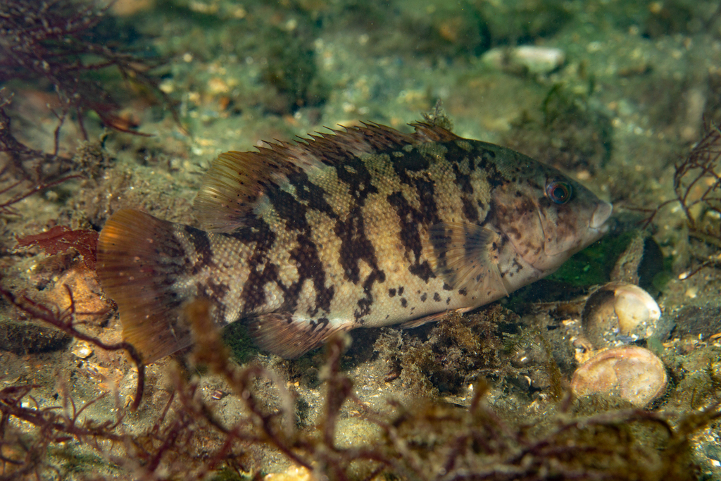
The tautog is labelled marine and brackish on the same environment line. It is not a fish that crosses into fresh water; it is a fish that uses the saltier end of an estuary as well as the open coast, and the record compresses that into two words. The fishing consequence is a question of position on a gradient that runs from ocean rock to bay rock, not a question of choosing between two separate waters.
One line, two salinities
FishBase records the tautog as marine and brackish, reef-associated, spanning 1 to 75 m, with a subtropical envelope from 46°N to 31°N. No salinity value is given. The line says the species can be found in both milieus, not where the boundary between them lies.
That omission is the centre of the entry. A "brackish" label does not say how brackish. It does not give a lower limit, an upper limit, or a seasonal shift. A reader who wants to know whether a particular bay mouth is too fresh for tautog will not get the answer from this line, and this entry will not supply a number the record does not carry.
Ocean rock and bay rock
Wikipedia describes the habitat as hard substrate in inshore waters, from 1 to 75 m, and notes that the tautog is the only species in its genus. The FishBase biology keywords are coastal, brackish and cave. Rock is the constant; salinity is the variable around it.
This is why the two labels sit together without contradiction. A boulder field inside a bay mouth and a boulder field on the open coast can both be hard substrate, both inside the 1 to 75 m band, and both hold tautog. The difference is how much fresh water reaches them, and the record does not map that.
The abundance core sits between two capes
The distribution text runs from slightly east of Halifax in Nova Scotia to South Carolina, and adds that the species is most abundant between Cape Cod and Delaware Bay. That speaks to density rather than to limits, and it puts the core in the middle of the range rather than at either end.
The core spans a stretch of coast with large estuaries and open rock in close proximity, which is consistent with the two milieu labels. The line does not show that salinity drives the abundance. The record gives no mechanism, and this entry will not invent one. iNaturalist carries 1,203 observations for this taxon.
Spawning in Chesapeake Bay, year-round
The spawning table has five records: Cape Sable to Block Island in May to July, Chesapeake Bay in every month of the year, Delaware Bay in June, near Woods Hole in June and July, and Virginia in April to July. The Chesapeake entry is the only one that runs through the calendar.
A year-round record in one bay and a spring-to-summer record on the coast do not carry the same weight. The table does not say whether the Chesapeake spawning is continuous or simply observed across the year in different fish. It also does not give a temperature or salinity trigger.
Five records along one gradient
Read the five entries as positions rather than as a single season. Cape Sable to Block Island is the outer coastal end; Woods Hole and Virginia sit near the same coastal stretch; Delaware Bay and Chesapeake Bay are the estuarine end. The months shorten as the records move outward and lengthen at the estuarine end, with Chesapeake carrying all twelve.
That pattern is visible in the table, but the table does not explain it. It could reflect water temperature, sampling effort, or the number of studies in each bay. The record does not choose, and this entry will not choose for it.
Depth 1 to 75 m, with the shallow end inside the estuary
The depth band starts at 1 m. On an open coast that would be a rock pool or a shallow ledge; inside an estuary it can be a channel edge or a pier pile. The band does not distinguish between the two, and the shallow end is where the salinity question becomes practical.
No usual-depth figure appears in the record, so there is no source-backed "most fish are at X metres" to plan around. What it gives is a maximum of 75 m and a minimum of 1 m, with the abundance statement tied to a stretch of coast rather than to a depth.
Maturity at 23.6 cm, age at 34 years
First maturity is 23.6 cm, with a range of 18 to 26.5 cm. The maximum length is 91 cm TL. Weight tops out at 11.3 kg, and the oldest recorded fish is 34 years. The common length is left blank.
The range spans 18 to 26.5 cm, and that spread tells a reader more than a single midpoint can. A fish at 20 cm may be mature or not, depending on which end of the range applies. The 91 cm maximum and the 34-year age describe a long-lived fish with a wide size spread, and the missing common length removes the usual anchor between them.
Where on the gradient to fish
Treat the two milieu labels as a direction, not a border: ocean rock at one end, bay rock at the other, hard substrate throughout. Use the abundance statement to narrow the coast to the Cape Cod to Delaware Bay stretch, and use the spawning table to see that the estuarine end carries the longest window. The record does not give the salinity at which the switch happens, so the boundary has to be found locally. GBIF's distributions layer narrows nothing: it adds only broad localities — the Western Atlantic, the Nearctic, and two named gulfs, Maine and Saint Lawrence — with no country rows to tighten the map.
Regulations before you keep it
These are the published regulations for this fish. Read the number first. The notice below it is the actual regulation.
Bag limit7
No minimum size · unlimited possession · all year
United States — federal (Atlantic) · US-FED-ATL
Federal Atlantic rules set no size or possession limit for tautog.
Tautog (Blackfish)
Open season: All year
Minimum size: None
Possession limit: Unlimited
16 in (one fish may exceed 21 in) · 3 fish Apr 1 – May 31 · 1 fish Jun 1 – Jul 31 · 3 fish Aug 1 – Oct 14 · 5 fish Oct 15 – Dec 31
United States — Massachusetts · US-MA
Massachusetts sets a 16-inch tautog minimum with season-specific daily bags of 3, 1, 3 and 5 fish.
Tautog (9) Min: 16"
Only one fish may
exceed 21" Apr 1 - May 31 3 fish
Jun 1 - Jul 31 1 fish
Aug 1 - Oct 14 3 fish
Oct 15 - Dec 31 5 fish
No minimum size · no bag limit
United States — Maine · US-ME
Maine sets no size or bag limit for tautog.
TAUTOG (Tautoga onitis)
Size: No minimum size
Bag limit: none
15 in · 4 fish Jan 1 – Feb 28 and Apr 1 – Apr 30 · 1 fish Aug 1 – Nov 15 · 5 fish Nov 16 – Dec 31
United States — New Jersey · US-NJ
New Jersey sets a 15-inch tautog minimum and phases the daily bag from four fish in winter and spring to one fish in early autumn and five fish from mid-November.
Tautog
15 inches
4 fish Jan 1 – Feb 28
4 fish Apr 1 – Apr 30
1 fish Aug 1 – Nov 15
5 fish Nov 16 – Dec 31
16 in · Long Island Sound 2 fish Apr 1 – Apr 30 and 3 fish Oct 11 – Dec 9 · NY Bight 2 fish Apr 1 – Apr 30 and 4 fish Oct 15 – Dec 22
United States — New York · US-NY
New York sets a 16-inch tautog minimum with 2-fish spring seasons and area-specific fall bags.
Tautog (blackfish): Long Island Sound Region
Marine and coastal district waters lying east of the Throgs Neck Bridge and west of a line that runs from Orient Point, NY to Watch Hill, RI 16" 2
3 April 1 - April 30
Oct 11 - Dec 9
Tautog (blackfish): NY Bight Region
Marine and coastal district waters lying outside of the Long Island Sound Region 16" 2
4 April 1 - April 30
Oct 15 - Dec 22
16 in (only one fish over 21 in) · 3 fish Apr 1 – May 31 · closed Jun 1 – Jul 31 · 3 fish Aug 1 – Oct 14 · 5 fish Oct 15 – Dec 31 · 10 per vessel
United States — Rhode Island · US-RI
Rhode Island sets a 16-inch tautog minimum, closes June and July, and allows 3 to 5 fish depending on the season.
3.10.1 Recreational
A.Minimum size: Sixteen inches (16”).
B.Maximum size: One (1) fish only may be greater than twenty-one inches (21”).
C.Season and possession limit:
1.January 1 through March 31: Closed.
2.April 1 through May 31: Three (3) fish per person per day.
3.June 1 through July 31: Closed.
4.August 1 through October 14: Three (3) fish per person per day.
5.October 15 through December 31: Five (5) fish per person per day.
16 in · 4 fish per person per day · closed May 16 – Jun 30
United States — Virginia · US-VA
Virginia allows 4 tautog per person per day at 16 inches and closes the season from May 16 to June 30.
TAUTOG
Minimum Size Limit: 16 IN.
Possession Limit: 4 per person
Season: Closed Season: May 16 - June 30
Every record above names its source and the date it was retrieved. See the regulation register for the full list, or how to read these regulations.
Where these facts come from
Check these pages before you rely on a size, range or protection status.
-
FishBase — Tautoga onitis
— FishBase · T2
-
GBIF — Tautoga onitis occurrence records
— GBIF · T2
-
IUCN Red List — Tautoga onitis
— IUCN · T1
-
Photo record — iNaturalist
— iNaturalist · T3